Kevin Barton, Landscape & Geophysical Services,
Dr Ralf Hesse, State Office for Cultural Heritage, Baden-Württemberg, Germany
Dr Žiga Kokalj, Institute of Anthropological and Spatial Studies, Slovenia
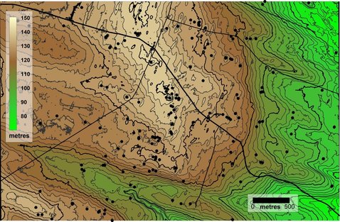
Rathcroghan landscape; computed topographic contours and the location of recorded
Monuments (Data sources - Ordnance Survey Ireland and Historic Environment Viewer).
Rathcroghan; a view from above
The presentation will be given by archaeological geophysicist Kevin Barton. He was Co-Director of the Heritage Council-funded ArchaeoGeophysical Imaging Project in the Rathcroghan Complex which carried out Ireland’s first multi-method remote sensing survey in the 1990s. He is currently involved in a number of hands-on local community remote sensing projects in Ireland and also projects in Germany and Poland.
The current project presented is using topographic and aerial data in an analysis of features and inter-monument visibility in a selected area of the Rathcroghan landscape. The work is based on contributions by the authors to the European Commission-funded ArchaeoLandscapes Europe Project (2010-2015).
For more information on the work of Kevin Barton, visit: lgs.ie/ & https://www.facebook.com/Community-Archaeological-Remote-Sensing-979573268823682/?fref=ts