Ruth Nugent: Dublin Institute of Technology
|
The use of surveying technologies for archaeological purposes
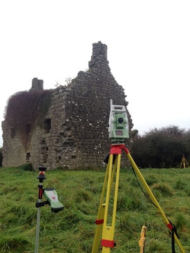
Ruth Nugent is a recent graduate of the BSc Geomatics (Geographic Science) course in Dublin Institute of Technology. For her dissertation, she has performed an investigation into the use of kite aerial photography for generating spatial data for archaeological purposes. For her research project, she carried out an extensive survey of Dundonnell Castle, Co. Roscommon using a variety of surveying technologies. During her presentation she will present the surveying technologies used which include GNSS, laser scanning and topographic surveying and will further discuss the results from her investigations including 3D point clouds, 3D models and other outputs.
|