Kevin Barton, Landscape & Geophysical Services;
Dr Katharine Keats-Rohan & Gerard Latham,
The Wallingford Historical and Archaeological Society (TWHAS);
Judy Dewey, Wallingford Museum
Wallingford Castle, Oxfordshire, England; Community-based remote sensing studies of the Inner Bailey
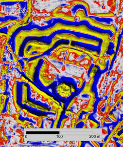
Figure 1 - Wallingford Castle - LiDAR Local Relief Model Visualisation
of the Motte, Inner & Middle Bailey and the Outer Ward.
Yellow/Red=Positive Relief, Blue=Negative Relief.
(Data Source: Environment Agency)
In the Wallingford area there is archaeological evidence of a presence dating from the Bronze Age. The town has its origins in Saxon times. A Castle was built at this strategic location on the River Thames soon after the arrival of the Normans in 1066. The Castle features in much of local history for the next 600 years until it was demolished in the mid-seventeenth century. Today the visible remains of the Castle largely consist of a motte, inner & middle bailey and outer ward with extensive high banks and ditches (Figure 1).
The rich history and archaeology of the area has been the subject of three primary publications with significant input by volunteers from Wallingford Museum and TWHAS. The first publication, in 2009, is of papers, primarily historical in content, from a TWHAS conference on the Origins of the Borough of Wallingford. The second publication, in 2013, reports the results from a large-scale project on the archaeology of Wallingford AD 800-1400. The third publication, in 2015, on the Castle and the Town comprises papers from a TWHAS conference which drew on extensive historical documentation about the Castle site. Arising from the historical and archaeological research, remote sensing and excavation there are questions still remaining about the structures and functional areas in the inner bailey which is the heart of the royal Castle.
The presentation will introduce the Castle, review the research findings relating to the inner bailey, the questions arising, new remote sensing visualisations and a new survey to be carried out in 2018. We will conclude with a short account on the development of Wallingford Museum, its day to day management and operation by community volunteers from TWHAS whose members will be involved in the new remote sensing survey.
For more information on this group and their work, visit:
http://www.twhas.org.uk/ & http://www.wallingfordmuseum.org.uk/